What the Zaragoza Bridge cameras show
Five fixed cameras from the agency that runs the bridge, all on the Juárez side, show the bridge with its cars and cargo, the toll booths, Avenida Waterfill and, in two views, the truck bridge. Together they cover the whole line, from the avenue to the bridge. The far end, in El Paso, is on that city's own cameras, which open on its page.
Toward El Paso: cars on one side, cargo on the other
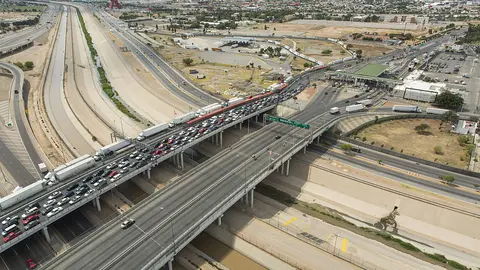
The camera looks north from the Juárez side and takes in both bridges at once. On the left are the car lanes crossing to El Paso, with the river levee alongside; on the right, set apart by a wall, is the cargo bridge, where tractor-trailers wait in a row.
It's the most useful view of the Zaragoza Bridge because it shows both lines at once. If the cars are spaced out, the crossing is flowing, even if there's a line on the cargo side.
The toll booths, seen from above
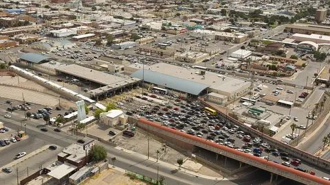
This one looks south, at the toll plaza on the Mexican side: the roof over the booths, the cars spreading out among them and, behind, the signs and shops of the Zaragoza area.
Here you see the first stretch of the line, the one that forms to pay the toll before getting on the bridge. If cars are waiting their turn at every booth, the wait starts right here; if they roll through without stopping, the line CBP is reporting is farther ahead, on the bridge.
Avenida Waterfill, before you reach the bridge
This camera shows Avenida Waterfill looking south, with shops along both sides: it's the road that leads from the city to the Zaragoza Bridge.
Most of the time you'll see normal traffic, and that's information in itself: it means the line fits between the toll booths and the bridge. When the wait is very long, the line can reach back to the avenue, and here you'd see it stopped.
Trucks lined up on the cargo bridge
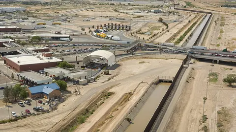
This is the cargo bridge camera. It looks north and shows the truck lanes, with tractor-trailers lined up toward U.S. customs.
For truckers, it shows how much of a line there is on the bridge before they get on; the cargo wait times, general and FAST, are at the top of the page with CBP's data. If you're crossing by car it doesn't affect you: trucks have their own bridge.
The truck approach to the cargo bridge
This camera shows the curve where tractor-trailers come up to the cargo bridge. You see them head-on, one after another, turning toward the camera.
It tells you whether cargo is moving out at a steady pace or trucks are sitting stopped before they get on the bridge. Together with the other cargo camera it gives you the whole line: this one shows the start; that one, the stretch on the bridge.
From the El Paso side: the line on the bridge and the CBP booths
The City of El Paso has three cameras of its own at the Zaragoza Bridge, on the U.S. side, and shows them on its website. The link opens that page in a new tab, right at the section for this bridge.
The first looks at the bridge from El Paso: the line of cars coming from Juárez and, next to it, the tractor-trailers on the cargo bridge. The second shows the approach to the CBP booths, the last stretch of the wait. The third looks down on the lanes for drivers heading into Juárez.
They're the other half of what the rest of the cameras on this page show, which look at the bridge from Mexico. On the city's page, each video starts when you tap its play button; close the tab and you're back here.
About the Zaragoza Bridge
Its official name is the Ysleta–Zaragoza International Bridge, after the two communities it connects: Ysleta, which El Paso annexed in 1955, and Zaragoza, now part of the Juárez urban area. CBP lists it as Ysleta. The first bridge here went up in 1938 and was rebuilt in 1955; the current ones date from 1990, when today's port of entry was also built. There are two four-lane bridges: one for trucks only and one for cars, with two sidewalks for pedestrians. The Mexican side is operated by the Fideicomiso de Puentes Fronterizos de Chihuahua (Chihuahua's border bridge trust), and the U.S. side by the City of El Paso.
Getting there and where it lets you out
On the Juárez side, you reach it on Avenida Waterfill, in Zaragoza. On the Texas side, the bridge comes out on Zaragoza Road, next to Loop 375, El Paso's beltway, which connects with I-10 without going through downtown. That suits anyone who lives, works or is passing through on the east side of either city.
Car, pedestrian and cargo lanes at the Zaragoza Bridge
By car there are three lines: the general lanes (CBP calls them "standard"), the Ready Lane, for travelers carrying a document with an RFID chip, and SENTRI, for those enrolled in that program. To use the dedicated SENTRI lane on the Mexican side you also need Línea Exprés. On foot there's a single line. And it's a cargo bridge, with a general lane and FAST, for enrolled carriers: within the city, trucks only cross here and at the Bridge of the Americas.
Best time to cross the Zaragoza Bridge
It's open 24 hours. CBP updates the wait time about every hour, and the arrow on each lane shows whether it's rising or falling.
If it's backed up, the Bridge of the Americas is about 9 miles upriver and doesn't close at night either; farther on, downtown, are the Paso del Norte and Stanton bridges. Downriver, the next crossing is Tornillo, about 19 miles away, which isn't open overnight. The El Paso bridge wait times page compares them all with the latest data.
Frequently asked questions
Are the Zaragoza Bridge and the Ysleta bridge the same?
Yes. Zaragoza is the name on the Juárez side and Ysleta the one on the El Paso side, which CBP uses.
Is there another Zaragoza bridge on the border?
Yes: the Veterans Bridge (Los Tomates), between Matamoros and Brownsville, is officially named for General Ignacio Zaragoza. The two are unrelated: they're at opposite ends of the Texas border.
What are the hours at the Zaragoza Bridge?
For cars and pedestrians it's open 24 hours, every day; the cargo lanes have their own hours. CBP's hours are at the top of this page, next to the wait times, and the page says so when the crossing is closed.
How much is the Zaragoza Bridge toll?
You pay the toll at the booths on the Mexican side. Chihuahua's bridge trust sets it and posts the current rates for cars, motorcycles, pedestrians and cargo on its toll page. We don't list them because they change.