What the Bridge of the Americas cameras show
There are three fixed cameras on the Juárez side: a wide view of the entrance to the bridge, the avenue where the line forms, and the Avenida Rafael Pérez Serna intersection. The view down the avenue is the one that best measures the line.
The lines entering the bridge, at a glance
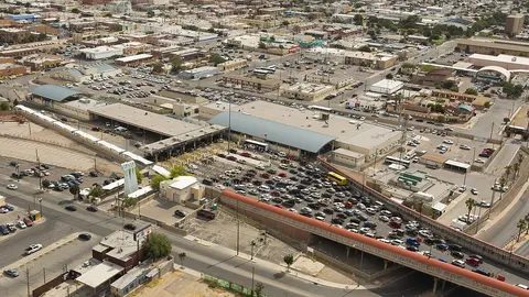
This is the widest view of the Bridge of the Americas. The camera sits up high on the Juárez side and looks north: below are the lines of cars making their way onto the bridge, spread across several lanes, and in the background, the city of El Paso.
Because it takes in the whole approach, it lets you size up the line at a glance: how many lanes are full and how far back the line reaches before the booths. The camera's owner notes on the image that it doesn't run this bridge.
The line stretching back along the avenue
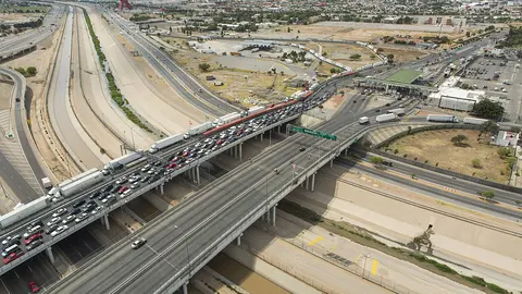
This camera looks south, down the wide avenue that leads to the Bridge of the Americas. The line into the U.S. forms in the lanes on the left of the image, up against the median and separated from the rest of the traffic by orange cones; the other lanes move normally.
It's the best camera for judging how long the line is: the farther down the avenue the row of cars reaches, the longer the wait.
The approach on Avenida Rafael Pérez Serna
This camera shows the Avenida Rafael Pérez Serna intersection, one of the routes to the Bridge of the Americas: a triangular traffic island with a garden in the middle, and cars turning around it to get onto the approach.
You can't see the bridge, but it helps you decide which way to come in: if traffic is stopped here, the line has already spilled off the main avenue. When few people are crossing it looks clear, like any other intersection in the city.
About the Bridge of the Americas
In the U.S. it's the Bridge of the Americas, which CBP shortens to BOTA. Its official name in Mexico is Puente Internacional Córdova de las Américas, and in Juárez people call it Puente Libre, the "free bridge," because it's the one with no toll. The crossing opened in 1967, with the Chamizal Treaty, which moved the river and the border here; today's bridges were built between 1996 and 1998. There are four structures: two four-lane bridges for cars, with sidewalks for pedestrians, and two two-lane bridges for trucks. It belongs to the International Boundary and Water Commission, and each side is operated by its own country's customs agency.
Getting there and where it lets you out
On the Juárez side, you reach it on Avenida de las Américas, the start of Mexico's Federal Highway 45, the Pan-American Highway. On the Texas side, the bridge is the start of I-110, which takes you to US 54 and I-10 in about a mile. That's why it suits anyone who isn't going downtown: you come off the bridge already on the freeway.
Car, pedestrian and cargo lanes at the Bridge of the Americas
By car there are two lines: the general lanes (CBP calls them "standard") and the Ready Lane, for travelers carrying a document with an RFID chip. On foot, the same two. There's no SENTRI lane: between Juárez and El Paso, enrolled travelers cross at the Paso del Norte Bridge, the Stanton Bridge or the Zaragoza Bridge. Commercial trucks enter through a separate facility, with a general lane and FAST, for enrolled carriers.
Best time to cross the Bridge of the Americas
For cars and pedestrians it's open 24 hours. CBP updates the wait time once an hour, and the arrow on each lane shows whether it's going up or down. With no toll and a direct connection to the freeway, it carries a good share of the traffic between the two cities: check the line before you head out.
If it's long, the Paso del Norte Bridge is about 2.5 miles upriver, downtown, and the Zaragoza Bridge about 9 miles to the east; both stay open all night. The El Paso bridge wait times page ranks them all from fastest to slowest.
Frequently asked questions
Are the Bridge of the Americas, BOTA, Puente Libre and the Cordova Bridge the same?
Yes. Bridge of the Americas is the U.S. name and BOTA its initials; Puente Libre is what people call it in Juárez, and Córdova is the short form of its Mexican name.
Where do commercial trucks cross between Juárez and El Paso?
Within the city, at the Bridge of the Americas or the Zaragoza Bridge. No cargo crosses at the Paso del Norte or Stanton bridges.
What are the hours at the Bridge of the Americas?
For cars and pedestrians it's open 24 hours, every day; cargo has its own hours. The hours CBP publishes are at the top of this page, next to the wait times, and the page tells you right there when the crossing is closed.